Webinar Overview: GeoInsurance Ireland – Part 1

Last year, Gamma hosted its first GeoInsurance Ireland event in Dublin, but this year—for obvious reasons—we couldn’t meet in person, so we went virtual, hosting the GeoInsurance Webinar Series 2020. The first two GeoInsurance Ireland webinars concentrated on advances in catastrophe modelling and the evolution of risk data, while the third, GeoInsurance & Climate Change, focused on climate change forecasting in the general insurance and reinsurance sectors. 

GeoInsurance Ireland – Part 1: New Models for New Times  

If you didn’t get the opportunity to check out the first GeoInsurance Ireland webinar, which focused on what’s new in geolocation for the insurance sector, and how advances in artificial intelligence are facilitating the development of new risk models, here’s a short overview. You can also watch it on-demand.

Artificial Intelligence for Earth Observation Data

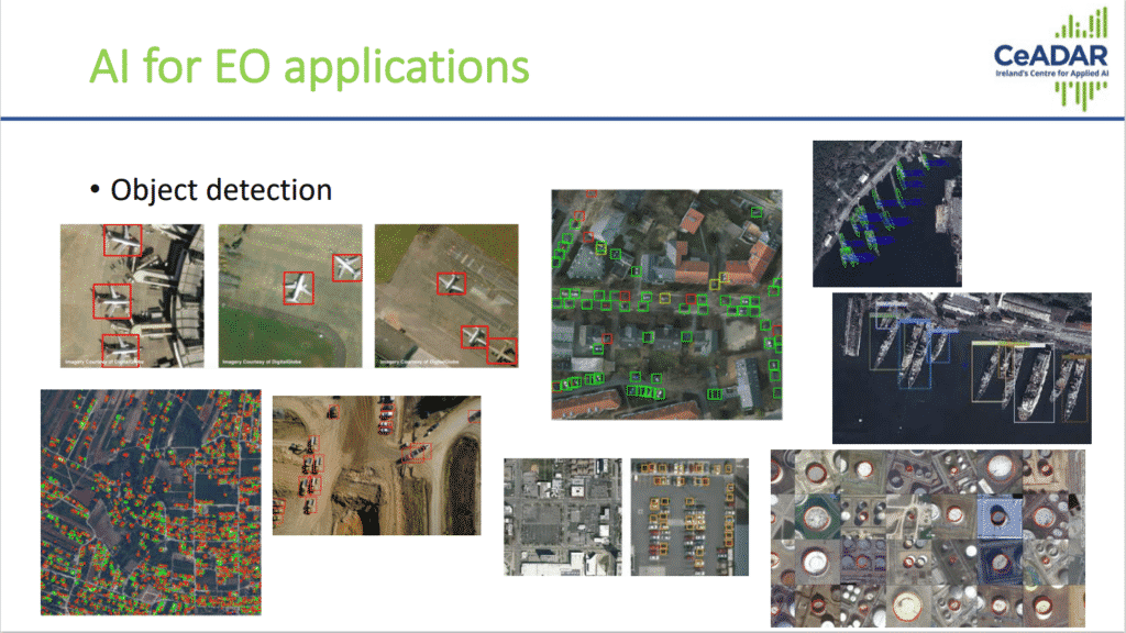
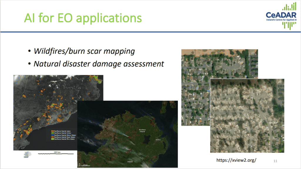
Our first speaker was Oisín Boydell, Principal Data Scientist and Head of the Applied Research Group at CeADAR, Ireland’s centre for applied AI at UCD. In his presentation, Oisín explained how CeADAR is applying AI to earth observation data so as to extract information on objects and ground cover. 

There has been considerable interest and progress in the application of AI techniques to earth observation data, with the purpose of deriving intelligence and insights, driven by the volumes, variety and accessibility of data, and developments in machine learning algorithms and approaches. Oisin demonstrated some of these applications, including object detection, land cover/land use mapping, and natural disaster damage assessment.

New Burglary Model using UK Data Patterns 

Next to speak was Charlotte Cuffe, Lead Consultant – Spatial Analytics Team, who heads Gamma’s modelling section. Charlotte has a wealth of experience in working with spatial data across Ireland and the UK. 

Charlotte’s team recently developed a new burglary model for the UK. In this presentation, Charlotte outlined what they had learnt from developing that model and how that knowledge had helped them build a much more detailed model for Ireland. Both stages are illustrated in the image below. 

On the right, you can see the new, fully trained machine learning model, which evaluates a set of risk factors and uses these to predict burglary risk. This results in a vast improvement in prediction accuracy, going from the map on the left, derived from the Garda station data with 564 ranked areas with different risk levels, through to the map on the right which incorporates over 18,000 distinct risk scores.

JBA Flood Map Updates

Vanessa Bambra, Property Search & Financial Sector Mapping Specialist at JBA Risk Management, described the upcoming flood map update for Ireland. This year, JBA began to remap the whole of the Republic of Ireland following the receipt of a new, up-to-date elevation data map. 

The team will continue up the west coast, mapping Limerick and Galway next, and aiming to remap the Republic of Ireland in its entirety within the next few years. JBA has also recently released a new model, Climate Change Analytics, which includes predictions of how flooding will change over the coming decades.

New Wind and Rainfall Risk Data for Ireland 

Last but not least, we were delighted to be joined by Jamie Banasik, Chief Executive Officer of Metswift, who presented their new wind and rainfall models for Ireland. Metswift use AI and meteorological data to build wind and rainfall models and have been active in the UK for a number of years. Recently, they have developed models for Ireland.

In his presentation, Jamie explained how wind and rainfall risk scores are adjusted locally and take into account the impacts of climate change specific to each weather type. Metswift risk information was also presented along with specific predetermined thresholds, making it suitable for the development of parametric risk and parametric insurance products.

You can watch this webinar on-demand.

@ 2020 Gammali.co.uk by Monika Ghita

About Gamma

Gamma is a Location Intelligence (LI) solutions provider; we integrate software, data and services to help our clients reduce risk through better decision-making. Established in Dublin, Ireland in 1993, and with offices in Manchester, UK and Bilbao Spain, the company has expanded to become a global provider of information systems, micro-marketing solutions and geographical analysis services. Gamma’s Perilfinder™ risk mapping platform is a leading-edge property level underwriting solution used by P&C insurers to assess environmental risk.