Gamma partners with BGS to extend their peril data portfolio offering for the UK market

Gamma, the location intelligence company, is pleased to announce they have recently become partners with the British Geological Survey (BGS). Gamma has integrated the BGS GeoSure Insurance Product range of subsidence datasets into their Perilfinder™ APIs and underwriting mapping solution to provide greater insights for their clients, as they continue their expansion into the UK market.

Perilfinder™ v.4.0, Gamma’s risk mapping platform, is a cloud-hosted property-level risk assessment tool for sub-second assessment of environmental risk. Building on its market-leading position across the island of Ireland, Perilfinder™ has recently extended its innovative platform to include the UK through partnerships with major risk data providers such as JBA Risk Management, Ambiental Risk Analytics, and now the BGS.

The BGS GeoSure datasets identify areas of potential hazard and, therefore, potential natural ground movement, within Great Britain. These data have been produced by BGS geologists and geotechnical specialists and are presented as six layers of mapping data relating to the cause of the geohazard. The ground movement, or subsidence, hazards included are landslides, shrink-swell clays, soluble rocks, running sands, and compressible and collapsible deposits. The partnership with BGS will help to enhance Gamma’s risk assessment offering and support its UK expansion. This partnership is part of the company’s £1.8 million investment in its Perilfinder™ platform.

Speaking about the partnership between Gamma and BGS, Richard Garry, Chief Commercial Officer, Gamma, said: “We are delighted to partner with BGS to provide such valuable data to our clients. Gamma aims to provide the insurance and financial market with the best data to help reduce risk when making location-based decisions. BGS GeoSure Insurance Products will enhance our peril data portfolio, providing an index-level assessment of the potential for a geological feature that can create financial insurance loss due to natural ground movement.”

Mike Ackroyd, Business Development Manager, BGS, said:  “The British Geological Survey is delighted that Gamma Location Intelligence has chosen to include the BGS GeoSure Insurance Products as part of their perils data offering as they enter the data market supporting the British insurance sector. We are confident that the valuable information provided by the BGS will add to the services offered by Gamma to its customers”.

@ 2020 Gammali.co.uk by Monika Ghita

About Gamma Location Intelligence

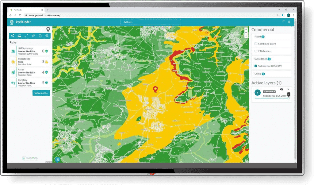
Gamma is a cloud-hosted solutions provider that integrates software, data and services to help our clients reduce risk through location intelligence. Established in Dublin, Ireland, in 1993, the company focuses heavily on leading-edge R&D including spatially aware AI and machine learning. Gamma has grown to become a market leader in the provision of location intelligence systems and services. Perilfinder™ v.4.0, Gamma’s risk mapping platform, is a cloud-hosted property-level risk assessment tool for sub-second assessment of environmental risk. Building on its market leading position across the island of Ireland, Perilfinder™ has recently extended its innovative platform to include the UK through partnerships with the major risk data providers.

About British Geological Survey

The British Geological Survey is a world-leading geological survey. It focuses on public-good science for government, and research to understand earth and environmental processes. It is the UK’s premier provider of objective and authoritative geoscientific data, information and knowledge to help society to use its natural resources responsibly, manage environmental change, and be resilient to environmental hazards. The BGS provides expert services and impartial advice in all areas of geoscience.